Originally Posted 10/11/2010
Cream Pot Access Trail (0.3 Mile) -> Mattabesset Trail (3.2 Miles) -> Lone Pine Trail (4.1 Miles) -> Mattabesset Trail (0.8 Mile).
10/10/2010

The Pyramid (Photo by Ahren Niles).
(Click photo’s to see full-size) We started the morning with a short walk up the Cream Pot Rd Access Trail again, turning left onto where we’d left off on the Mattabesset Trail. The hike started off crossing and/or walking on various tote roads weaving our way through Mountain Laurel. All of a sudden we came across a huge, and I do mean huge, glacial erratic to the left of the trail. This was clearly the Pyramid marked in our Walk Book. After taking pictures, and discouraging Side Track from attempting to scale the erratic, we began the strenuous climb to the Mica Ledges. The Mica Ledges were really nice and offered us a nice view, which I imagine would have been nicer prior to a large area of tree’s having been knocked down in order to create a neighborhood of cookie-cutter homes.


Courageous Chloe in the tiny scrub pine. (Photo by Ahren Niles)

Selectmen's stones
Towards the end of our walk along the Mica Ledges we stopped to sit and soak up the sun and enjoy a much needed lunch break before taking off down from the ledges; which is where we found the tiniest scrub pine I’ve ever seen! I quickly decided this is where Courageous Chloe would have
her picture taken this week. Just before the descent we ran into another item of interest marked in our Walk Book, the Selectmen’s Stones. These stones are piled at the corner where Durham, Gilford, and Madison, CT all meet. “These stones provide evidence that the boundaries of the three towns were walked and verified by the selectmen as late as the early 1900′s. …Maps were few and the population largely illiterate so perambulation was a means of impressing boundaries on parishioners” – CT Walk Book.
her picture taken this week. Just before the descent we ran into another item of interest marked in our Walk Book, the Selectmen’s Stones. These stones are piled at the corner where Durham, Gilford, and Madison, CT all meet. “These stones provide evidence that the boundaries of the three towns were walked and verified by the selectmen as late as the early 1900′s. …Maps were few and the population largely illiterate so perambulation was a means of impressing boundaries on parishioners” – CT Walk Book.

We left the Mattabesset Trail about a mile later to continue on the Lone Pine Trail. We’ll come back later & hike in to where we left off to finish this sections of the Mattabesset. The Lone Pine Trail passes through several Nature Preserves so there are a number of trail intersections. I would imagine on a warm spring, or summer day you would run into a number of people here. On this chilly Sunday morning though we ran into no one at all. Shortly after switching over to the Lone Pine Trail we ran across an old Coal Site. It was like a little mini-museum of the Charcoal Site that was here from the 1700′s – 1930′s.


Awesome cliff.
After spending some time checking out the charcoal site we continued on down the Lone Pine Trail where we ran into a really awesome looking cliff with some neat bent, vertical striations. I love the things we run into on hikes. Things you could never see from a car, this is a good part of the draw for me. Anyway, continuing on down the trail, we had spent most of the day in hardwood forest and were still in a hardwood forest when we suddenly found ourselves staring at a single, huge, pine tree standing proudly in the middle of this hardwood forest. This huge pine three is the Lone Pine for which the trail is named!! Yay! I had to hug it.


Lunch Rocks (Photo by Ahren Niles)
After I hugged the tree we continued on & ran into “Lunch Rocks”, eventually proceeding down and crossing Rte 77. At this point the trail follows along the bottom of the mountains we will hike on top of next time we hike the Mattabesset Trail. This section of the trail is pretty bland & seems less maintained. We crossed several puncheon bridges, one of which had become crooked and kind of moved back & forth as you crossed. Not too unsettling but probably will become so if it goes too much longer without being repaired. We also ran across a lovely farm with a couple of horses grazing in one of the pastures. I stopped to pet the one horse who showed interest in me and came to the fence. He quickly lost interest in me just as soon as he learned that I didn’t have anything for horses to eat and went back to grazing.


Stone wall made from Trap Rock. (Photo by Ahren Niles)
We passed the Buffalo Tree which is an old Shagbark Hickory Tree which has two burls that look like buffalo. Then began our ascent, or so I thought, to the plateau of Totoket Mtn. Come to find out though, we would ascend quite a bit, then descend all the way back down to cross a stream in a huge, beautiful ravine, before ascending again to the top of Totoket Mtn. On Totoket Mtn we found ourselves surrounded by, and hiking on, Trap Rock. Trap Rock, while neat, is very annoying to hike on. It’s a constant struggled not to slip, trip, or turn your ankles. I hate hiking on trap rock! In order to complete all of CT’s 825 miles of blue trails though I must hike on it as there are many trap rock mountains in this part of CT and the blue trails happily criss-cross them. The rest of the days hike was pretty uneventful. We lost the trail at one point due to poor blazing and a criss-cross of ATV trails that are in this area. Side track hiked back to the last blaze we had seen & found where we’d gone wrong while I took a rest on a log at the edge of the trail. The hike ended with a walk down Rte 17 where I found a $20 bill laying on the side of the road. Side Track walked right past it just as I spotted it, stopped, realized it was real & pocketed it. I’ve never gotten paid for hiking before. There was no one around to claim the twenty as theirs so off towards home we went.
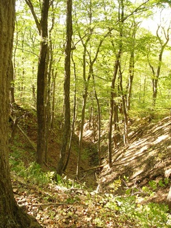
Small ravine on the way out. (Photo by Ahren Niles)

 RSS Feed
