Originally posted 03/14/2011
Hiked on: 03/13/2011
A little over 6 Miles
For our completion of the Westwoods trails we decided to Park on Peddlers Road and take the White Circle Trail in to meet up with the Yellow Circle Trail, which we followed until we met up to the Violet Circle Trail. We then followed the Violet Circle Trail back to the Green Rectangle Trail until it met up with the Yellow Crossover Trail, which took us back to the Yellow Circle and we backtracked along it, to the White Circle and back to our car. Confusing as it sounds it made for a nice loop.
Maps of this Trail System are available in the CT Walk Book East and at the following website: http://guilfordlandtrust.org/wordpress/properties/westwoods
One thing to note is that the CT Walk Book states that the Yellow Circle Trail is the most challenging trail in the Westwoods trail system and as such “is recommended only to the agile and energetic hiker”. This is no joke! Do not attempt this trail unless you are experienced, agile, energetic, and willing to get a little dirty. Now I will mention that there are bypasses around the most difficult area’s, though they are unmarked which means they are unofficial, so take caution if choosing to use them.
Hikers are strongly encouraged to pick up a trail map before setting out!
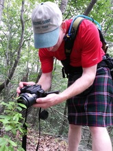
Now, for the fun part, pictures of our hike!
Maps of this Trail System are available in the CT Walk Book East and at the following website: http://guilfordlandtrust.org/wordpress/properties/westwoods
One thing to note is that the CT Walk Book states that the Yellow Circle Trail is the most challenging trail in the Westwoods trail system and as such “is recommended only to the agile and energetic hiker”. This is no joke! Do not attempt this trail unless you are experienced, agile, energetic, and willing to get a little dirty. Now I will mention that there are bypasses around the most difficult area’s, though they are unmarked which means they are unofficial, so take caution if choosing to use them.
Hikers are strongly encouraged to pick up a trail map before setting out!
Now, for the fun part, pictures of our hike!


 RSS Feed
